|
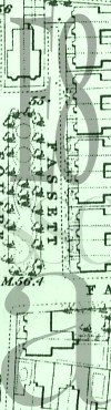
1870 : A section of the 1870 Ordnance Survey of Dalston.
Select the above link to view the map.
Interesting things to notice on the map include : The row of houses on the west side of the square, which were demolised to make way for the German Hospital in 1935, were only ten years old when this map was drawn up.
Also, the cartographer drew in the trees and formal flower beds of the Victorian garden.
The section of map was scanned from The Godfrey Edition of the Old Ordnance Survey Maps. London sheet number : 40. Published by Alan Godfrey Maps, 57 Spoor Street, Dunston, Gateshead, NE11 9BD.
|
|